Christmas Lake/CRWEC 9/28/2019

Rattlesnake Ledges

A combination of sore toes and bad weather have kept me off the trail since I returned from Ireland but yesterday I gingerly put a toe (so to speak) back into the hiking world by doing a little Christmas Lake hike prior to an afternoon Cedar River Watershed Education Center (CRWEC) tour of the former town of Cedar Falls.

The tour was great. It was a short one, only 2 hours, and we didn’t go far. The former town of Cedar Falls is only a short distance from the Education Center, but we (about 17 of us, plus Anna and Julie, our guides and drivers) climbed into two vans for the short trip down the road.

Cedar Falls was created as a company town in the early 20th century to house the workers and their families who tended to the power generating equipment in the watershed that sent power to Seattle. In addition to power, of course, the watershed sent water to Seattle. Following the devastating fire of 1889, made worse by the lack of water and water pressure, the residents of Seattle almost unanimously agreed to get their water from 30 miles east of the city.

Remnants of Cedar Falls

Cedar Falls, in addition to being a railroad stop:

RR Stop of Old

… was a nice little community with tennis courts, an indoor swimming pool, a school and a great sense of community, attested to by those residents who, in later years, left oral histories. They also had what appears to be a very early version of a hot tub:

Early Hot Tub?

We also visited the remains of an old cabin, formerly used to house temporary watershed workers (like fire fighters). The interior held remnants of the old days:

Old Stove

All in all, a nice day and it felt good to get out again, even if my first hike after Ireland was very gentle. Gentle or not, I love the views you get out there such as:

Near Christmas Lake

Only about a 4 mile hike, not much elevation gain, and more or less aimless. The track shows a little loop:
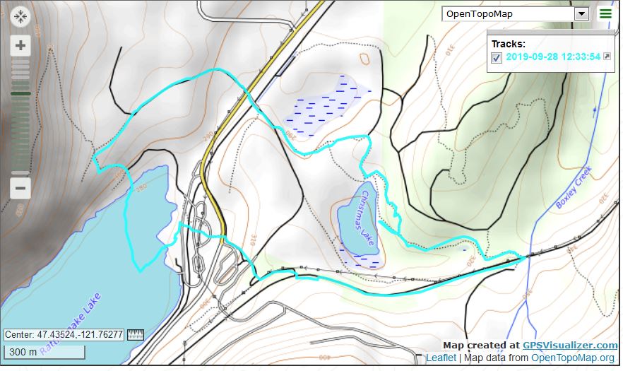

Track

I plan to get out next week at least a couple of times and build up to a more robust experience on the trail. And, as always, hurray for the CRWEC!

Wicklow Way 9/6/2019

Dublin in the Distance

On Friday morning, 9/6/19, we were dropped by taxi back at the Crone car park and it was a short walk to get back on the Wicklow Way.

Just like the first two days, the third day was wonderful from start to finish. At just over 14 miles it was the shortest day, which gave our aching feet (legs were fine but some toes and arches were starting to complain) just a bit of a break.

As we headed up the shoulder of Dublin Mountain, nearing the end of the journey, we saw a sign that reminded me of a friend with whom I had had lunch the previous week who, upon hearing I was going to hike in Ireland, said ‘At least it will be a level walk because there are no mountains in Ireland.’

Did They Mean ‘Dublin Hill’?

It was with mixed feelings that we approached the end of our journey. We hated to admit the amazing experience was ending, but our bodies (particularly the old man’s) were suggesting we take a bit of a rest.

Elusive Mountain

One visual guide for us was the mountain above, which we saw repeatedly from different elevations and points of view. It is not all that far west of the Irish Sea and it looks like a great destination for a future trip.

We did not hike the entire length of the Wicklow Way; we did a bit more than half, 53 miles/85 km. At one point we passed a sign that marked the exact middle of the Wicklow Way.

All along the way are helpful trail markers. When in doubt, look for one of these signs:

The Helpful Guide

To Wicklow walkers I suggest using a great map guide, such as the guide we were supplied by Hillwalk Tours as a supplement. Not every sign is very obviously visible (undergrowth expands, of course) but if you follow your progress on the map and know where to expect twists and turns, the maps plus the Wicklow posts are pretty much on the money. We grew to love that little yellow walker.

Finally, we came down and down and down and landed in Marley Park which, we noticed, adjoins a nice looking golf course, as seen on Google Earth below this picture of the Marley Park map:

Marley Map
Marley and Vicinity

Here are the topo and Google Earth tracks:

Topo Day 3
Google Earth Day 3

According to the MyGPS web site, the combined elevation gain for all three days was 12,342 feet. That kind of feels like more than it was. On the other hand, the Wicklow Way is (look at an elevation profile online if you choose) quite a bit of up and down and up and down.

One of the steepest sections was at Miner’s Way, which we did in the teeth of yet another tough wind and sideways rain. In fact, I was wearing my jacket around my waist and was in short sleeves during the worst of this stretch. I knew I should put on the jacket but it was so windy I was afraid if I tried to put it on it would blow away. So I just got cold and wet.

So it goes on the Wicklow Way.

Finally, this was without a doubt the greatest road experience of my life and, I believe I can say the same for Derek. We have no specific plans to do anything like this again, but we were idly speculating about a possible future trip to the west coast of Ireland, in the area of Dingle Town….

Wicklow Way 9/5/2019

Glendalough Lakes

Unlike the first and third days of the hike, we were able to start our day under our own power on day two. We left Riverside B&B and re-traced our steps from the day before, up Green Road towards Glendalough. Derek took many pictures of this historic location and if I get some will post them.

After checking out Glendalough we got back on the Wicklow Way and, as we hiked up and up, looked back to see the Upper and Lower Lakes from above (see above photo).

The weather on day 2 was pretty much perfect all day, except for the bracingly energetic wind. And just like day 1, the world through which we walked was magical.

Typical Landscape
Irish Flowers
Look at That!
Just Wow

Here are our topo and Google Earth tracks from day 2, which landed us at Coolakay House, another outstanding B&B, in Enniskerry:

Topo Track Day 2
Google Earth Day 2

Speaking of the Coolakay B&B, after we settled in, Derek grabbed the Garmin and took a walk on the property – it includes a working sheep farm – to a nearby prominence from which he enjoyed a great view. I didn’t join him because, having done 19.5 miles that day and being 67 years old (we added mileage at the start of the day by detouring to Glendalough) I thought it best to sit back. Here is the Google Earth view of Coolakay and vicinity:

Coolakay

Another day of steep ascents, steep descents, moderate-to-level trail and roads – just a cornucopia of hiking experiences, truly a day to remember.

We had taken a taxi from the Crone Car park to the B&B and the same taxi brought us back the next morning so we could begin day three of our Wicklow walk.

Wicklow Way 9/4/2019

Wicklow Landscape

Derek and I landed in Dublin on Monday afternoon, 9/2/19, took a bus to our hotel and spent the rest of the afternoon exploring Dublin. We must have walked (per Derek’s iPhone app) about 10 miles. A nice warm-up for the actual hike.

On Tuesday we took a train to the town of Rathdrum, gazing most of the way at the beautiful Irish Sea – we were heading south along the coast. When we got to Rathdrum we walked to our B&B, Stirabout Lane, an exceedingly charming little bed and breakfast (our favorite of the trip) and set the terms for the start of the hike on Wednesday.

Daphne, Stirabout’s terrific proprietor, drove us to Iron Bridge, our starting point. We found the Wicklow Way very easily and had a nice, steep stretch right away. We had gone about 2 miles or so when we ran into a detour, caused by logging operations in the area. (BTW, Daphne explained that the law in Ireland is that for every tree removed, a new one must be planted. Nice!)

We consulted our maps about how to proceed and Derek, always a stout navigator, found the way and we were back on the official trail in less than an hour.

It is difficult to describe just how marvelous the entire Wicklow experience was – Dublin, the B&B’s we enjoyed, the small towns, and of course the hike (or hill walk) itself. All I can do is post a few pictures (Derek took hundreds of photos and may share some later) and hit the highlights.

One highlight of day 1 was sharing the trail with sheep:

Sharing the Trail

The flowers along the way were spectacular:

Wild Flowers

A continuing feature of the Wicklow Way, encountered in many places, was boardwalk:

Boardwalk

At one point, I think on day 2, we were trudging uphill on a boardwalk, through a bog, with winds that I estimate to be steadily blowing in the range of 35 or 40 mph, the strongest continuous wind I have ever encountered. Staying out of the bog was a challenge and our pace slowed to a crawl.

We made 19 miles the first day, ending up in the village of Laragh, which is just on the edge of the famous Glendalough, where Jan and I stopped last year on our Rick Steves tour. The site of our B&B, Riverside B&B was a sight for sore feet:

Riverside B&B

Riverside was also a wonderful place to stay – nice room, great breakfast and our hosts were knowledgeable and friendly.

Below are images of our first day track, topo and Google Earth:

Day 1 topo track
Day 1 Google Earth

The photos and images above are very pale representations of the reality. On the ground in Ireland we enjoyed almost continuous beautiful views, and smells, and feelings. The most energetic weather, by far, was on day 1. It was windy and the fronts moved through in rapid succession.

It was raining when we started and I put on my rain pants and poncho. Nice protectors but they do trap heat. It wasn’t long before I ditched all of the weather gear and opted for the more streamlined approach, because, the weather being so changeable, if it was a problem right now it wouldn’t be in ten minutes.

We were staying right next door to Glendalough, with its famous old tower, other sacred buildings and graveyard. We were too beat when we arrived to hike back to Glendalough (about 2km away) but that’s where we started on Day 2.

Ireland Itinerary

In less than an hour I will be leaving the house and will go to SeaTac airport via bus and light rail to catch a plane to Dublin.

Derek and I are going to spend some time in Dublin and then hike (hill walk to use the local, Irish vernacular) for three days on the Wicklow Way, the Republic of Ireland’s longest trail (we only do a portion).

9/1 – flight to Dublin, land on 9/2.

9/2 – spend the night near the Connolly train station, see whatever sights we can in about a half day.

9/3 – train from Connolly to the town of Rathdrum, where we stay in our first Hillwalk Tours B&B.

9/4 – B&B personnel will drive us to Iron Bridge, the start of our Wicklow Way hill walk. We will walk to the vicinity of Glendalough, the town of Laragh, to stay in a B&B there.

9/5 – Get back on the Wicklow Way and walk to the town of Enniskerry, where we stay overnight.

9/6 – Again back on Wicklow Way and hike to the northern terminus of the Wicklow Way in Marlay Park, south Dublin.

9/7 – We are extending the trip an extra day by staying at our last Hillwalk Tours hotel.

9/8 – Check out of hotel, get to airport to fly back to Seattle.

More detail on our route:

https://www.hillwalktours.com/hiking-ireland/wicklow-mountains-5-day-challenging-hike

As always before an overseas trip I am a bit hyper and nervous, but Derek and I are both looking forward to what will almost certainly be an incredible journey.

I will be posting pics and info here when I get back.