Granite Lakes 5/29/2019

Upper Granite Lake

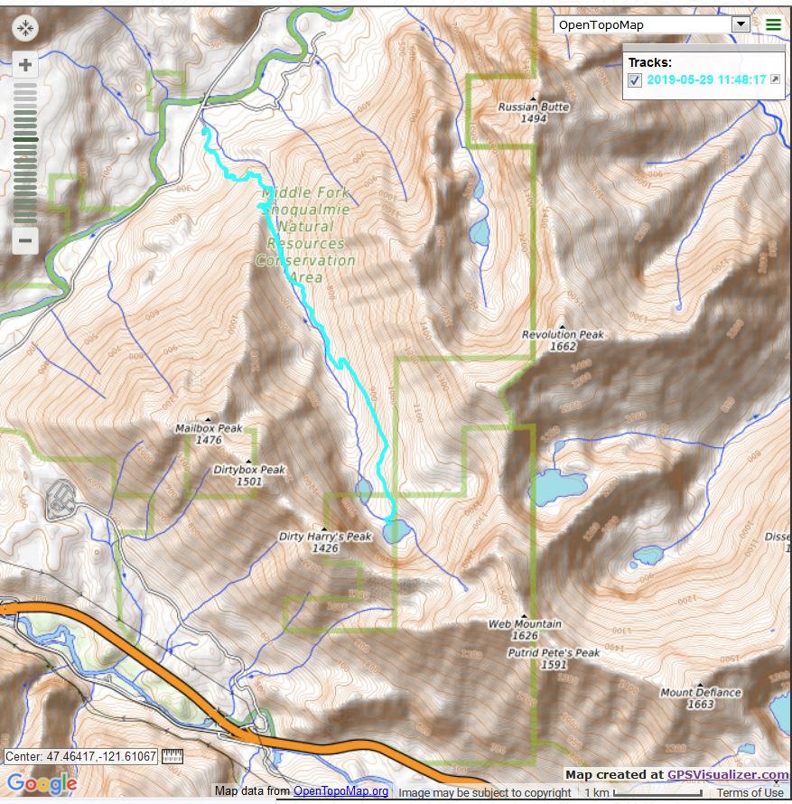
My plan today was to hike to Granite Lakes by taking the connector trail to the Granite Creek Trail but I didn’t notice the trail head as I drove by (it is just a wide spot in the road) so I wound up starting from the Granite Creek Trail Head.

That’s quite OK because the connector trail adds 1.3 miles each way, and because it is longer it is not as steep. A close look at the track below shows that the first 1.4 or so miles of this hike are fairly steep but then it shallows out.

This is a very nice trail and it was a good workout. Granite Creek is a loud (at this time of the year at any rate) companion for most of the way:

Granite Creek

The Granite Lakes are sub-alpine lakes in the area known as the Middle Fork of the Snoqualmie River. When you get to the lake you are in effect in a bowl. Wherever you look, you see the tall mountains that surround the lakes:


Looking Up

On the way down I saw a great example of how nature renews itself. There were several young trees growing out of an enormous old-growth stump:

New Trees Growing Out of the Old

It was a nice, fairly cool day. I saw about 8 or 9 folks the entire hike. This area is jam-packed on the weekends. In fact, since this trail is just down the road from the massively popular Mailbox Peak, on a sunny weekend just getting into and out of the area is a challenge, with all the people parking along the sides of the narrow road. But today, well, not so much.

A bit more than 8.5 miles and 2,769 feet of elevation gain. Here is an image of the track:

Track

Fun day!

PTC Trail/Mine Creek Bridge 5/27/2019

Mine Creek Bridge

The weather was so beautiful on Memorial Day that I opted to do a nice little 5-miler, parking at the Olallie Park south picnic area, going up the Hall Creek Connector Trail, and then east on the Palouse-to-Cascades (PTC) trail. This trail used to be called the Iron Horse Trail (and the John Wayne Pioneer Trail).

I love the Mine Creek Bridge. It is a beautiful bridge and it is in an awesomely scenic spot. When you stand on the bridge and look south:

Looking South

You see the mountains that surround you, including Chester Peak (attaining that summit is one of Derek and my goals), as seen above.

When you look north:

Looking North

You see the mountains on the other side of the freeway, such as Dirty Harry’s Peak and Mailbox Peak.

On the way back, heading west, I got a nice view of Mount Si (pointy prominence on the left) and Mount Teneriffe (pointy prominence on the right):

Mount Si and Mount Teneriffe

I plan to go to Granite Lakes tomorrow, 5/29 and if all goes as planned, Teneriffe on Saturday, June 1. And June 1 is the combined birthday party for granddaughter Finley, who just turned 10, and Camden, who is about to turn 4.

Should be a great day!

Squak Mt. Double Traverse 5/23/2019

West Peak Trail

Today I “officially” started training for the Irish adventure. We will be doing about 18 miles a day, each day, for three days. Whew!

So today I parked at the Margaret’s Way parking lot, off SR900, with a plan to go all the way across the mountain to the SE May Valley Road Side, and back.

On the way out, I went up the Margaret’s Way trail to its end at the Chybinski Loop and then went right and took the Perimeter Loop Trail, my first time on that one. It was fine except for one very serious blow down. I wound up crawling on my belly underneath, as going over it looked even tougher, with several branches obstructing the path over this massive tree. Old growth? Perhaps – it was big. I should have snapped a photo, but I was wrapped up in getting past the obstacle.

This trail hit the Bullitt Gorge Trail, which hit the May Valley Loop trail and I took that one to its beginning, just .1 mile from the parking lot on that side. I took a quick break and just turned around.

On the way back I skipped the Perimeter Trail due to the blow down and substituted the West Peak Trail. I have done that trail from the other direction a few times, today was the first time from this direction. It is steep!

But then I finished that section back at the Margaret’s Way Trail and cruised back, the 2.76 miles. Saw some nice flowers along the way:

Flowers

Here is an image of the track, which was 11.9 miles, 3,300 feet of elevation gain:


Track

You can see it is basically an out-and-back except for the loop around the word ‘Squak Mountain West Peak 608 [meters]’. I took the lower section on the way out and the upper section on the way back.

A nice workout. I need to pile on the mileage and work up to 3 days in a row.

Spring Comes to the Watershed 5/18/2019

Looking East

Yesterday I participated in the Cedar River Watershed Education Center’s (CRWEC) tour “Spring Comes to the Watershed.” This was the second year of this tour and I was on the first one last year.

Last year it took place in early June and the weather was interesting, alternating between sun, rain, hail, and sleet, but this year it was less interesting and more enjoyable, sunny and warm the entire time (9am to 4pm).

Rolf Gersonde once again led the tour, this time assisted by Julie Stonefelt. Julie filled us in on some of the human history of the watershed. For example, she told us that fire pits dating back thousands of years have been uncovered in the watershed.

Rolf’s theme was that spring comes to the watershed at different times in different areas. After all, not every place in the world features huge differences in elevation, and as elevation varies, so do the weather and the temperature, among other factors. The flora and fauna of each ecological niche is unique.

We stopped several times, and each stop was its own learning experience. Rolf took us to two meadows, and the difference in the meadows, which were adjacent on the side of the mountain, were striking.

High Mountain Meadow


The first meadow, pictured above, had quite a bit of standing water and countless numbers of frogs, tadpoles, and proto-tadpoles. The second meadow, slightly lower in elevation, was bisected by a small stream. The stream and its banks had plants that existed nowhere else.

Another stop was at a tremendous view point at 3200 feet:


Looking North

We who hike in this area on a regular basis are accustomed to attaining summits and other views and looking south into the Watershed, which is of course off-limits. It is only on rare occasions like this tour that we can visit the watershed and look north at our regular vista points.

A visit to an old growth stand was also special:

Old Growth Stand

Rolf and Julie were so generous with the time – at each stop we had plenty of opportunity to just sit back and enjoy the moment. I spent about fifteen minutes transfixed by a small waterfall, just watching the endlessly changing water tumble down the mountain:

Waterfall

We saw quite a few birds and heard many more. Rolf identified more than a dozen species based on their calls. And we got to see four Turkey Vultures drifting along on the air, high above:

Turkey Vultures

I am looking forward to my third Old Growth Forest tour in August. I do not understand why these tours are not more popular than they are. We had only eight people in the group:

Heading to the View

Perhaps the CRWEC is more about the Watershed than the publicity.

In either case, as long as I and these tours exist, I will be enjoying them, learning from them, and relishing the opportunity to approach nature with the appropriate level of humility.

Tiger Mt./Talus Rocks 5/16/2019

The Rocks

I did my usual conditioning hike today on Tiger Mountain but I added the extra mile or so (total hike was 6 miles) by adding the Talus Rocks Trail. This trail hits the Tiger 3 trail so I took Tiger 3 down to the Bus Trail and back via Wetlands Trail.

As always, the forest is beautiful:

The Forest

Nice way to start a Thursday.

Songbird Peak 5/9/2019

Looking North from Songbird Peak

I hiked up to Songbird Peak today with Carl. What a great hike! The weather was perfect, although towards the end it was a bit warm. Summer is coming.

We hiked up the Mount Washington main trail to the Great Wall connector trail. From there we went to the new bike trail, which was mostly deep, semi-slushy snow, and then to the Great Wall which did have a couple of snowy sections but overall was not too bad.

We skipped Change Peak and Mount Washington and headed straight to Songbird.

Plenty of things to see along the way, including a great view of Rainier:


Mount Rainier

Here is what the snow looked like:

Carl in the Snow

13.17 miles, 4,410 feet of elevation gain, per the Garmin (seems a little high to me). About 7 hours total – not bad, we spent about 30 minutes on Songbird to have some snacks, catch our breath, and marvel at the view. It is almost 360 degrees and wherever you look it is nothing but mountains and trees.

Marvelous!

Dirty Harry’s Museum 5/7/2019

Dirty Harry’s Truck

On rare occasions I feel as if the current situation is perfect. I could not improve it if I tried. Today, for about an hour, I felt that way.

My plan this past Friday, when I did a short hike prior to babysitting, was to hike to Dirty Harry’s Museum on Sunday. But we wound up hosting our grandson Camden overnight on Saturday into Sunday afternoon – a nice alternative.

So today I decided to try to find Dirty Harry’s Museum. The weather was excellent, approaching 70, blue skies, not too hot, not too cold. I encountered no snow on this trail.

The Dirty Harry’s Peak Trail has a lot to offer. In addition to four basic destinations – you can stop short at the balcony, go a little farther to the museum (which is just Dirty Harry’s old truck, Dirty Harry having been a logger long ago), farther yet to his “bathtub” (a tarn north and east of the Museum) or all the way to the peak. The trail also hooks into numerous side trails used by rock climbers. On weekends the place is packed – a couple of weeks ago, Derek and I showed up on a Sunday at 8:30 am and the lot was full.

Anyway, I did find the path to the museum, thanks to a recent trip report. Some kind soul has put small cairns (piles of rocks) to mark the way through the trees. It is only about .3 mile from the main trail and voila! There is the truck.

I hit the main trail about 7:30 and was alone for the entire way up, except for a couple of young people who, faster hikers than me, passed me on their way up to, I assume, the peak.

This is a great trail and it offers amazing views along the way:


Peaks to the South
Looking West

The view from the Balcony is awesome. Prominent is McClellan Butte and, immediately east, Mount Kent:

McClellan Butte

6.71 miles, 2,769 feet of elevation gain.

What made that perfect hour was this: when I got back to the car and fired it up, the radio came on automatically. In fact, I don’t know how to set it to not come on automatically.

It was tuned to the local classical music station and what should I hear but the very first notes of Beethoven’s 6th Symphony, the Pastoral. My all-time favorite piece of music!

So I cranked it up and, driving home via the back route, through Carnation and Duvall, I was as happy as I can be. A wonderful solo hike, nothing but sun and fun, topped off with such a serendipitous musical moment.

UPDATE: Forgot to add a picture of the route, via my Garmin:

Track

Tiger Mountain Loop 5/3/2019

Tradition Lake

Listing the route I took yesterday on Tiger Mountain makes it sound like a grueling hike – Nook Trail to Section Line to Bonneville Powerline to Wetlands to Puget Power to Around the Lake – but it was only about 5 miles with most of the elevation gain on the Nook.

I hit the trail from the High Point parking lot at 5:50 am. My plan that day was to do my bi-weekly gig as a babysitter in Snoqualmie but Jill’s work schedule has been changed and she wanted me there at 9 rather than the usual 8. Leaving home an hour later would get me bogged down in commuter traffic so I decided to do a hike a few miles from their home in the early AM.

I am glad I did. It really started the day right, and I spent the day with Camden (his sister was in school) who is almost 4 and a total delight. We are great pals.

I hope tomorrow to find Dirty Harry’s Bathtub, a small lake between Dirty Harry’s Peak and Web Mountain. If I can find the lake, Derek and I can go back there some day and find a way to summit Web Mountain.