
Derek and I landed in Dublin on Monday afternoon, 9/2/19, took a bus to our hotel and spent the rest of the afternoon exploring Dublin. We must have walked (per Derek’s iPhone app) about 10 miles. A nice warm-up for the actual hike.
On Tuesday we took a train to the town of Rathdrum, gazing most of the way at the beautiful Irish Sea – we were heading south along the coast. When we got to Rathdrum we walked to our B&B, Stirabout Lane, an exceedingly charming little bed and breakfast (our favorite of the trip) and set the terms for the start of the hike on Wednesday.
Daphne, Stirabout’s terrific proprietor, drove us to Iron Bridge, our starting point. We found the Wicklow Way very easily and had a nice, steep stretch right away. We had gone about 2 miles or so when we ran into a detour, caused by logging operations in the area. (BTW, Daphne explained that the law in Ireland is that for every tree removed, a new one must be planted. Nice!)
We consulted our maps about how to proceed and Derek, always a stout navigator, found the way and we were back on the official trail in less than an hour.
It is difficult to describe just how marvelous the entire Wicklow experience was – Dublin, the B&B’s we enjoyed, the small towns, and of course the hike (or hill walk) itself. All I can do is post a few pictures (Derek took hundreds of photos and may share some later) and hit the highlights.
One highlight of day 1 was sharing the trail with sheep:

The flowers along the way were spectacular:

A continuing feature of the Wicklow Way, encountered in many places, was boardwalk:

At one point, I think on day 2, we were trudging uphill on a boardwalk, through a bog, with winds that I estimate to be steadily blowing in the range of 35 or 40 mph, the strongest continuous wind I have ever encountered. Staying out of the bog was a challenge and our pace slowed to a crawl.
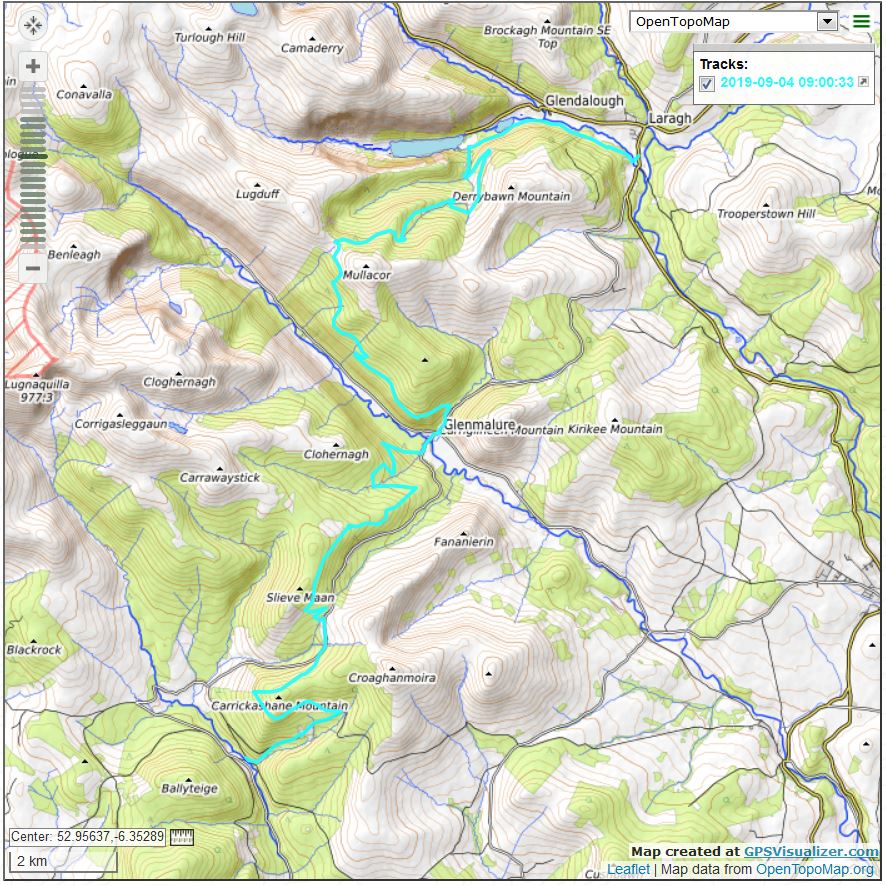
We made 19 miles the first day, ending up in the village of Laragh, which is just on the edge of the famous Glendalough, where Jan and I stopped last year on our Rick Steves tour. The site of our B&B, Riverside B&B was a sight for sore feet:

Riverside was also a wonderful place to stay – nice room, great breakfast and our hosts were knowledgeable and friendly.
Below are images of our first day track, topo and Google Earth:

The photos and images above are very pale representations of the reality. On the ground in Ireland we enjoyed almost continuous beautiful views, and smells, and feelings. The most energetic weather, by far, was on day 1. It was windy and the fronts moved through in rapid succession.
It was raining when we started and I put on my rain pants and poncho. Nice protectors but they do trap heat. It wasn’t long before I ditched all of the weather gear and opted for the more streamlined approach, because, the weather being so changeable, if it was a problem right now it wouldn’t be in ten minutes.
We were staying right next door to Glendalough, with its famous old tower, other sacred buildings and graveyard. We were too beat when we arrived to hike back to Glendalough (about 2km away) but that’s where we started on Day 2.