W. Tiger #2 and #3 1/29/2019

West Tiger #2 from West Tiger #3

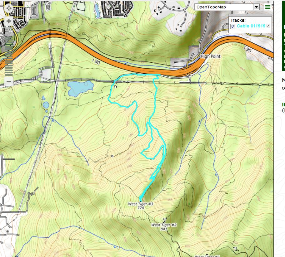
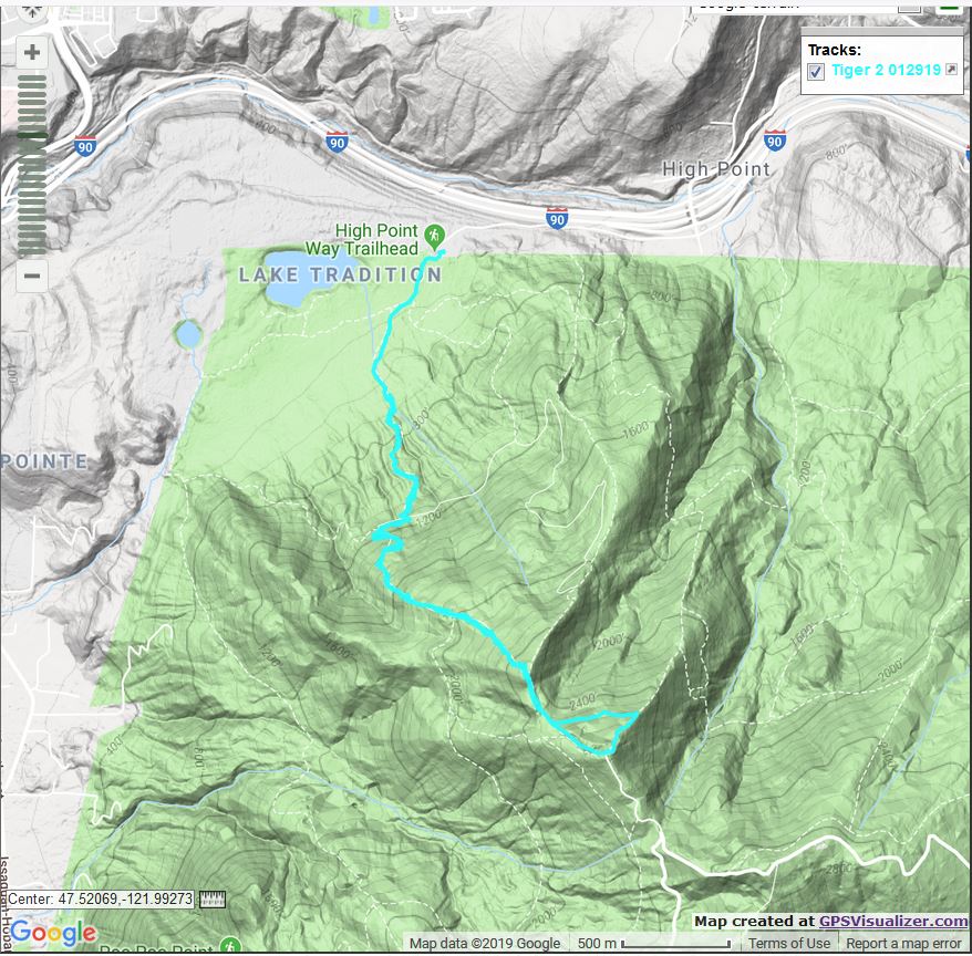
We did a loop today (sort of): up the Nook Trail to the Section Line to the summit of West Tiger #3 (the western-most of Tiger Mountain’s six distinct peaks) then looped around the east end of Tiger #2 to that summit and then back to #3, then down the way we came up.

It was me, Ken, Greg, David and Mike today, although, because I am slower than them I started about 20 minutes ahead of them. Turns out we both made it to #3’s summit in about 90 minutes.

As always, I love love love being in the forest:

The Forest

The spot above is just below the junction between the Cable Line Trail and the Section Line Trail, about fifty yards from the Tiger #3 summit. The sign on the left says ‘Unmaintained Trail’.

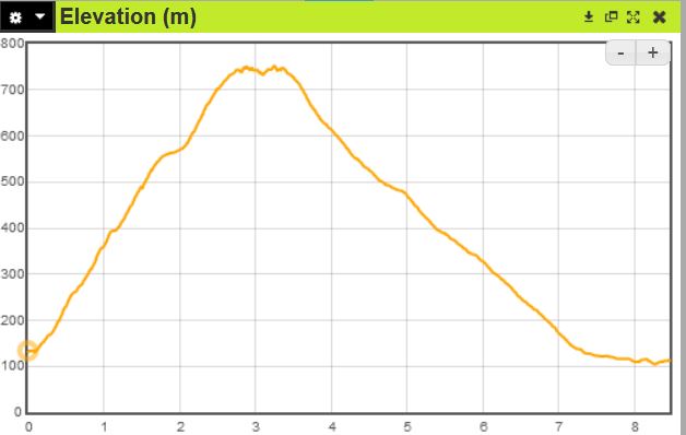
We did about 5.2 miles, here is a shot of the track:


The Track, Tiger #3 on the left, #2 on the right

A fun hike and a great workout, since the Section Line trail is way steep.

Tiger Mountain/Section Line 1/27/2019

Hazard of the Trail

Fairly short solo hike today (Jan and I went to a play yesterday afternoon so I skipped the standard Saturday hike with the usual suspects), Section Line down the Nook Trail.

I encountered the above broken tree limb on the Bus Trail and thought: how bad would your timing be if you happened to be on the trail at the exact time the limb fell?

It happens – last year a guy was killed by a falling tree on the trail I hiked on Thursday, Twin Falls – but I don’t think the probability is very high. Here is where the limb came from:

The Source

One other note, I passed Round Lake along the Wetlands Trail and was glad to see it is is close to being back to its normal size. It is a small lake again rather than a big puddle.

Twin Falls 1/24/2019

Upper Falls

I did a solo moderate hike today, Twin Falls. The only truly memorable event today was the fact that I investigated a little side trail I had seen many times, always telling myself “some day….” and today was the day.

The Twin Falls trail starts at a trail head accessed from I-90 Exit 34 and ends at what is now the Palouse to Cascades (PTC) trail just west of the Mount Washington trail head, Exit 38.

A few yards east of the Mount Washington trail head is a little trail that goes – where? Many is the time I have seen it and wondered and told myself that I would check it out some day.

Today when I got to the PTC I walked east, just to get a little more mileage in, and as I went past the Mount Washington trail I noticed the mystery trail and headed up.

It was rough, to put it mildly. It was steep, straight up the mountain, and rugged. I had to climb over several huge downed trees. It didn’t go very far, but at the end of the navigable territory was a huge rock. Very interesting rock and I took some photos which, unfortunately, were blurry.

I had to conclude that this trail, like the trail a few yards west of the Mount Washington trail, were created by hikers looking for and not quite finding the Mount Washington trail which is notoriously difficult to notice (I missed it on my first solo hike up Mt. Wa), particularly in the dark.

But the answer to the mystery is: this trail goes nowhere.

I noticed a very pretty section of the forest on the way down:

Along the Twin Peaks Trail

Just under five miles, about 1,200 ft elevation gain. Here is a Google Earth view of the track:

The Track in Blue

Tiger Mountain/Cable Line 1/19/2019

Resting Near the Summit

The plan today was to meet at the Tiger Mountain Cable Line trailhead at 7:30. I got there about 7 and texted Ken (above, closest to the camera) that I was going to start early. Ken and Greg are both faster hikers than me and I figured I would get a little start so they wouldn’t have to wait for me.

The Cable Line trail is justly famous around here among hikers for being rough (totally unmaintained and seriously eroded for most of the way) and steep. It is about 2,000 feet of elevation gain in roughly 1.5 miles. Check out the elevation profile (distance is in km, elevation gain in meters):


I kept wondering when someone would catch up with me but in fact I made it all the way to the summit, waited there a few minutes and started back down when I finally saw Greg coming up, with Ken right behind.

The summit was windy and a little wet so we retreated down the trail a little way to a former camp site, rested, and then hiked down via the Tiger 3 trail – the same trail I went up on Tuesday.

Here is the track with the ‘up’ on the right (east) and the down on the left:


Track

Nice way to start a Saturday, very strenuous on the way up, a great stroll through a beautiful forest on the way down.

West Tiger #3 – 1/15/2019

NE View from Trail

Retirement isn’t all roses but this morning I was focused on the good news. It was Tuesday and I didn’t have to go to work. I could go outside and play, which for me means go hiking.

I have hiked down from the Tiger #3 summit via the Tiger #3 trail but I have never gone up that way. So today I reversed a previous route where I had gone up the Section Line and down Tiger #3. Here is the track, with ‘up’ on the right (east):

Today’s Track

The summit of Tiger #3 does not offer the greatest views but there is a bit of a look west, towards Bellevue, Seattle, and the Olympics if you look hard enough:

Summit View

One reason I have avoided this trail is because it is notoriously crowded. But I figured early Tuesday (I hit the trail at 7:21 am) would be an exception and I was right. I probably saw about a dozen people all day, and no one at all on the very steep Section Line that I took going down.

No need to guess the elevation of Tiger #3:

Summit Sign

All in all it was a terrific way to start the day, just under 5 miles (3 miles up, 2 miles down) and 2K elevation gain. 2.5 hours, a decent workout.

Rattlesnake Mountain/Grand Prospect 1/5/2018

View From Grand Prospect

I’ve done this hike solo a couple of times in recent weeks but today I was with Carl, Ken, David, Mark and Greg. Had a great time.

Ken, Greg and Mark added extra weight to their packs as they are training for an assault upon Mount Shasta in June. Mount Shasta is a proper mountain climb where they will be bringing ropes and crampons and really rocking out.

Today was much gentler but still lots of fun. On the way down we passed Sally Jewel, Obama’s Secretary of the Interior on her way up. Very cool!

Above is the view from Grand Prospect (about 3,300 feet elevation) here is what the place looks like as you approach:

View Of Grand Prospect

Just under 8 miles, in spite of the photo above there was actually not much snow on the trail until we were almost at Grand Prospect.

Looks like Tiger 2 for next weekend and I am thinking of doing something Monday, when the weather may be more or less favorable.

Mt. Washington New Year’s Day 2019

Mountain With Snow

What a great way to start the new year. I hiked with Mike, Mark, Greg, and Ken up Mount Washington. There was a lot of snow starting about 2,000 feet and we had to stop to put on our spikes. But the trail was packed down pretty well and we definitely were not sorry we left the snow shoes at home.

The trail was absolutely gorgeous, a true winter wonderland.

On The Trail

There were plenty of people on the trail and why not? Holiday, sunny, what’s not to love?

Chester Morse Lake (source of most of Seattle’s water)

We stayed on the summit for a few minutes and then headed down:

Descending From the Summit

On the way down I was sad thinking about my friend’s son’s death. My friend, under other circumstances, might have enjoyed a hike like this. All we can do is take advantage of the opportunities we have and hope for the best.