Change Peak via Change Creek 4/28/2019


At the Change Peak Summit

The kids stayed with us on Saturday night and Jan took them into Seattle on the bus for a fun day at the Art Museum, Aquarium and the big ferris wheel downtown. That left the door open for me and Derek to plan a hike.

We were going to do Dirty Harry’s Peak, a hike neither of us had ever done (although I have been to Dirty Harry’s Balcony) but when we got to the parking lot it was full.

So we drove back down the road 1/2 mile to the parking lot we use when we hike Change Creek. We were the only car in the lot.

We were not sure how far we could get, given the possibility of difficult snow conditions, but basically we just kept pushing on and dealing with whatever the trail threw at us.

There was definitely a lot of deep snow but it was consolidated and we rarely post-holed. We spent most of the time in the snow walking on top.

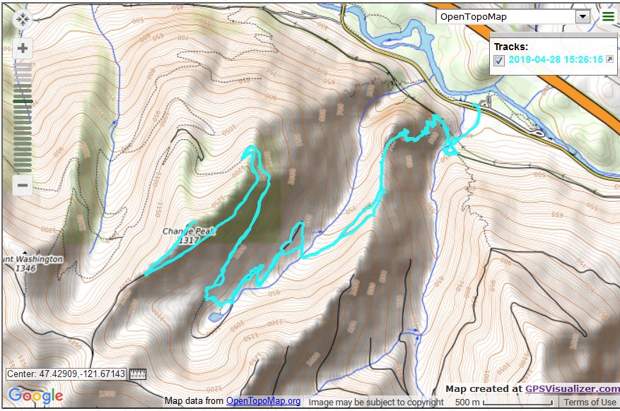
And what a nice hike. We wound up, per the Garmin (which seems a little heavy on the elevation gain) doing 10.9 miles and about 4,500 feet of elevation gain. It surely felt like it.

This part of the world is outstanding:

Looking North
McClellan Butte


West from Change Creek Trail

This was a terrific workout. In fact, we were pretty exhausted at the end but that’s the way it goes when you do this kind of thing.

Here is a look at our track via GPSVisualizer.com:

Track

Definitely a fun hike!

Tiger Mountain/Section Line 4/21/2019

Nice Day

I have a class on Monday, doctor on Wednesday, wet forecast for Tuesday so I figured I would follow up yesterday’s hike with my standard conditioning hike this morning – Tiger Mountain/Section Line.

Great weather and a really nice way to start a Sunday (whether Easter or not). I went down the Nook Trail, which is a fairly typical Tiger trail:

Nook Trail

It is still spring, summer has not dried up Round Lake:

Round Lake

Just before I got back to the E. Sunset connector trail (the steep but short connection from the E. Sunset Way parking lot to the Puget Power Trail) I noticed the little view point on a sunny day. This is looking west over Issaquah and Lake Sammamish:

Looking West

Spring!

Rattlesnake Mountain 4/20/2019

Awesome Forest

There was quite a crowd this morning. Ken and Wendy were there, along with their son and daughter-in-law from New Jersey (there to visit the newest member of their family, Ken and Wendy’s new grandson via their other son and daughter-in-law) plus Mark and Greg.

Their plan was to hike only up to Stan’s Overlook, since the out-of-towners are not accustomed to hiking on mountains. I left them at Stan’s and continued on towards Grand Prospect (although I turned around a bit before Grand Prospect, it was starting to rain and I had not brought my rain gear). I have said before, I just love the forest above Stan’s and today, on a cloudy, misty day, they were beautiful and mysterious.

The typical northern view along the service road that bypasses the trail below Stan’s was not much of a view today:

Fog

Yesterday I was in Snoqualmie babysitting and I was supposed to bring a bag of Easter candy. I forgot – my bad. But Derek was around this morning and I stopped by briefly after the hike to drop off the candy. The kids were there, looking longingly at the candy, but dad said they had to wait until tomorrow.

The cruelty!

Hoping for more hikes next week.

Teneriffe Falls 3/16/2019

Teneriffe Falls

I did a solo hike today. My plan was to hike up to Teneriffe Falls via the standard trail, but take the Connector Trail back to the Mount Teneriffe Trail on the way down. Assuming I could find the connector trail.

Which I did, thanks to my Gaia app. This mapping app showed me where to look but finding the trail – more like a very faint bootpath – was not easy. The intersection is at the point where the standard trail is closest to the stream that cascades downstream from the falls. Even today, with the water running high, I was able to cross without much trouble.

(I will briefly mention the fact that you can get too close to these falls. People have died trying to get just a little bit better of a picture. I am paranoid about falling hundreds of feet onto wet rocks so I stayed back a few feet for the picture above.)

Anyway, finding the “trail” on the other side was not easy. Eventually I got it straightened out and from then on the path was fairly clear. It did intersect the Mount Teneriffe trail, but about 2 miles from the parking lot. I had estimated that taking the connector back would save about .4 mile but instead it added about that distance. I think I will forget this trail for most purposes as it was not all that exciting and added little value.

One nice point about this hike is there are a few spots with a view towards the mountains south of Teneriffe:


Three Peaks

From L-R: McClellan Butte, Change Peak, Mount Washington.

I was reminded why I wear sturdy hiking boots – this trail has several very rocky sections:

Rocky Trail

I wouldn’t want to tackle this stuff with tennis shoes (and I have seen people on this trail and others like it with scant footwear) because it would slice up my feet.

Here is a Google Earth view of my track (blue) today. I went up and then to the right to the falls, then partway back down the track goes left (west) on the connector trail, then back down the Mount Teneriffe Trail.

Track

6.58 miles, 2,545 feet of elevation gain, a decent hike and workout for a Tuesday. (beats working!)

Tiger Mountain 3/13/2019

No pictures today, Ken, Mark and Mike and I did the Adventure Trail/Section line hike to the junction with the Nook Trail and back.

We had planned, for the second week in a row, to hike to Granite Lakes, which is about 9 miles, but once again it was raining so hard we decided to do a much shorter hike. We got soaked but not as bad as it would have been had we done Granite Lakes.

I am hoping for some better weather in the next week so I can get back to thrice-weekly outings.